By: Louisa Gaylord
UW School of Oceanography Professor LuAnne Thompson and recent PhD graduate Hillary Scannell are leading a team that uses data science to track and predict marine heatwaves (MHW). These extreme hot-water events have had dramatic ecological impacts and have led to widespread toxic algal blooms, habitat degradation, and loss in commercially valuable fisheries. The ocean absorbs and stores the majority of excess heat in our climate; as the overall ocean temperatures have doubled over the past four decades, these heatwaves have grown more frequent and severe.
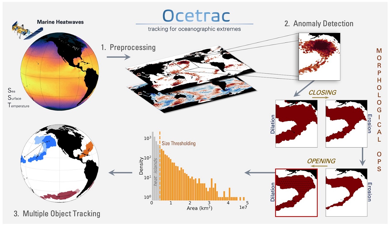
Scannell and Thompson are able to track MHWs in both time and space by studying their morphology and evolution. To do this, they rely on sea surface temperature (SST) data from a blend of satellites, ships, and in-situ instruments. “We detect temperature extremes when SST exceeds the local monthly 90th percentile relative to a climatology defined from 1981-2020. We then use morphological image processing to extract connected extreme values, creating a dataset of 2D MHW objects connected in space,” Scannell says. “We then calculate the area of each identified MHW object and eliminate MHWs that fall below a certain area threshold. The remaining 2D MHW objects are then connected in time.”
Scannell and Thompson developed an end-to-end Python package called Ocetrac that tracks dangerous marine heatwaves globally. The package was developed in collaboration with scientists of the National Center for Atmospheric Research (NCAR), and with the use of their supercomputer Cheyenne and compute cluster Casper. The team combined several Python packages to address various tasks: xarray to handle and manipulate the multidimensional data, scikit-image to label connected MHW images in time and space, and SciPy image processing to detect the edges of the 2D MHW images. “Ocetrac provides insight into the spatiotemporal evolution of MHWs worldwide, which is ripe for machine learning applications and the eventual forecast of MHW,” says Scannell. “We plan to further develop Ocetrac in the future to track other extreme events such as harmful algal blooms. This package will be open-source and available to the public by the end of the year.”
By using morphological image processing on global sea surface temperature datasets and using Azure to accommodate their workflow, Scannell and Thompson’s project will aid scientists in better understanding the effects of MHWs and develop methods to predict how they form and grow. This research could inform disaster and emergency responders, as there is a link between MHWs and hurricanes, as well as to help mitigate the negative impact of future biodiversity events such as mass mortality of benthic lifeforms. In fact, Microsoft has awarded the project one of their AI for Earth grants that will lead to the implementation of innovative AI models that address critical environmental issues, can rapidly scale and will create lasting impact beyond the grant period.
Since the 1980’s when satellite observations provided researchers with a new view of the ocean, advances in technological capabilities have rapidly changed how data science is conducted. “There’s a potential for supervised machine learning approaches to better quantify subsurface variability by combining Argo profile data with satellite observations,” says Thompson. “Different areas of the ocean have different characteristics with respect to MHW behavior. We have been using K-means clustering to learn the dominant spatial distribution of the processes that control air-sea exchange of heat, again from satellite based surface observations. The sub-surface observations are too sparse to be able to ascertain this directly from observationally constrained ocean heat budget.”
While LuAnne Thompson and Hillary Scannell are using Python packages to further their oceanography work, data science can provide transferrable skills and knowledge to many areas of study such as statistics, physics and computer science. “Data science is a powerful skill set and widely applicable to many disciplines. I would highly encourage students to explore data science along with their studies,” says Scannell. If you’re interested in learning more, start with a basic Software Carpentry Workshop or specialized hackathon. The UW is also offering a new Data Science minor in the Fall 2020 quarter to give students the data analysis tools they need to understand the metrics of their specific fields.