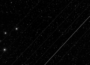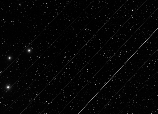
The recent growth of low-Earth-orbit satellites is posing a threat to a range of groups who rely on the sky for science, spirituality and tradition, by leaving a plethora of bright streaks across the night sky. A project team at the University of Washington Data Science for Social Good (DSSG) program is working this summer to create a satellite streak detection algorithm that will serve as a tool for quantifying changes in the sky. This tool is aimed at supporting people in astronomy and other fields to take steps to mitigate the prevalence of streaks and their negative effects.
The increase in satellite streaks stems from the industrialization of space, which leaves markings that are visible to both telescopes and the unaided eye. The satellites, which are aimed at purposes such as improving internet access for people in remote areas, affect astronomical imaging by impacting the ability to observe and analyze astrophysical phenomena from Earth. For many Indigenous communities, satellite streaks compromise the relationship between people and the cosmos.
The project, “Satellite Streaks in Astronomical Images,” is one of four projects hosted this year by the eScience Institute. The DSSG program brings together students, stakeholders, data scientists and domain researchers to work on project teams for 10 weeks each summer. The project team consists of three student fellows from universities around the country, a data scientist at the eScience Institute, and two project leads from the UW Department of Astronomy.
Interdisciplinary Learning
A variety of academic backgrounds on the team provided the opportunity to bring new insights to the project tasks, including work with astronomical images, and facilitated a deep learning experience for participants.
Fellow Abhilash Biswas, a graduate student at Heinz College at Carnegie Mellon University, said, “One of my learning goals for this summer was to improve my computer vision skills, and I am happy to see myself firmly on that path. Working on detecting satellite streaks in astronomical images has improved my understanding of how a machine treats an image, the various methods to manipulate images, and being aware of the background math of image processing techniques.”
Fellow Ashley Santos, an undergraduate student in the Computing, Data Science and Society Department at the University of California, Berkeley, said, “As an undergrad, I haven’t yet had the opportunity to apply what I learned outside the classroom. Being a DSSG fellow on the Satellite Streaks team has allowed me to build onto my Python programming and mathematical approaches, which are critical skills that I am learning to develop as I consider post-grad opportunities such as graduate school or going into industry.”
Fellow Kilando Chambers, an undergraduate student in Applied Mathematics and Psychology at Harvard University, worked during the program to increase his Python programming skills, explore how data science and Python are used to solve complex social problems, and improve his understanding of computer visualization and image processing, and how they relate to statistical analyses and machine learning.
Project Co-Lead Meredith Rawls, a research scientist in the Department of Astronomy and the Institute for Data Intensive Research in Astrophysics & Cosmology (DiRAC) at UW, described the diversity of backgrounds as an asset to the project. “I’ve really appreciated the fellows’ willingness to dive into a new, challenging problem in an unfamiliar field. The other project lead and I are both astronomers, and having an interdisciplinary team with zero expectations about astronomical image processing has been rewarding. After a few short weeks, the fellows are able to harness bits of our domain knowledge, hone in on important questions, and start producing really promising results. I’m thrilled they have taken the initiative to connect with some of my colleagues to learn more about software and analysis techniques as well as bigger picture implications of how satellites are changing our skies,” she said.
Combining Technical, Astronomical and Social Considerations
Completing the Satellite Streaks project requires a multifaceted approach. Streak measurements are complex, and may include trail length, width, angle of velocity, and degree of arc, while social impacts are similarly expansive and span a range of concerned groups.
To gather background information and ground their project in real-world context, the team met with multiple stakeholders. They began by meeting with an undergraduate student at Harvey Mudd College and a Ph.D. researcher at the Vera C. Rubin Observatory who are conducting a project this summer to estimate streak brightness, led by DSSG Project Co-Lead Meredith Rawls. Through this meeting, the team learned about the telescope planning process and how to predict satellite streaks, measure their properties, and build knowledge and skill in astronomy when coming from other fields.
To learn about the impacts of satellite streaks and the industrialization of space on indigenous communities, the team spoke to a Yaqui and Ph.D. researcher in Native American Systems of Knowledge and Information Science. Through this meeting, the team learned about the importance of the night sky in Yaqui traditions, and how satellite streaks compromise the relationship between indigenous communities and the sky. They also learned about concerns over pollution at launch sites and satellites falling back into the atmosphere.
The team also met with several additional astronomers whose work focuses on measuring and minimizing the negative impacts of satellite constellations on astronomy and the night sky, and a postdoctoral fellow who is working on an image analysis and processing technique to detect satellite streaks. Through these meetings, the team learned about prior work in this area and the programming and technical aspects of detecting streaks.
Project Co-Lead Dino Bektešević, a graduate student in the UW Department of Astronomy, said, “Discussions with stakeholders on the technical nature of the data we are processing has shed light on the nuances of measuring and, specifically, calibrating brightness of satellite trails. I see satellite constellations primarily as a social issue, touching on humanity’s relationship with nature, so stakeholder engagements on topics of cultural and social issues caught my attention the most.”
Data science support is also key to the project’s success. Vaughn Iverson, a research scientist at the eScience Institute, said one of the unique aspects of working with the data for this project is, “The images produced by the custom cameras scientific telescopes are extremely high resolution and are stored in a specialized file format that familiar image processing tools don’t support.” As the team’s data scientist, he also helped improve team collaboration between members who are using a variety of operating systems. “We solved this problem by standardizing using Linux through the use of software containers and professional remote access tools for software development.
The team’s work to measure the brightness of satellites in a variety of images will assist with the study of how streaks are changing over time and inform future mitigation strategies, including policies and regulations. The final outputs of the project will also include the public release of images with measured streak parameters, providing a direct resource to astronomers who conduct work on satellite streak mitigation.
The final DSSG presentations will take place on Wednesday, August 17th via Zoom from 1:00 to 3:00 p.m. Pacific. The event is open to the public. Registration is required.

