Project Lead: George Brencher, UW Civil & Environmental Engineering
Data Science Lead: Scott Henderson
Glacial lakes are distributed in alpine terrain worldwide and are frequently dammed by unstable glacial moraines. These moraine dams can fail, causing lakes to rapidly drain and flood downstream valleys. Glacial lake outburst floods (GLOFs) are a significant hazard for high-elevation infrastructure and communities—on October 4, 2023, a GLOF in Sikkim, India, destroyed the Teesta III hydroelectric dam, washed away 15 bridges, affected hundreds of villages, stranded 3,000 tourists, and left at least 74 dead with many more missing. This flood was triggered when a landslide on a glacial moraine catastrophically failed and fell into the South Lhonak Lake, causing it to breach its banks. The landslide had been moving downslope at rates of up to 10 meters per year since at least 2016, but was not identified prior to its collapse, despite multiple flood hazard and risk analyses for the site.
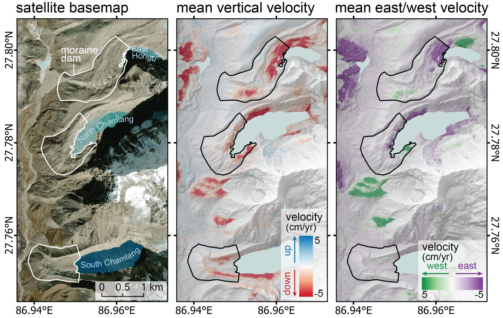
Using satellite synthetic aperture radar remote sensing, we have developed a workflow allowing us to quantify surface changes that can contribute to GLOF likelihood, including landslide movement and moraine dam subsidence. Our approach fuses interferometric synthetic aperture radar (InSAR) and SAR speckle tracking data to accurately capture deformation as fast as hundreds of meters per year and as slow as <1 cm per year. During this incubator project, we developed infrastructure to deploy our workflow on the cloud using Github Actions, allowing us to quickly and efficiently process large radar datasets and create surface displacement time series. We applied this processing pipeline to measure surface displacement from 2017-present day with high spatial and temporal resolution for the areas surrounding selected hazardous glacial lakes in Nepal, India, and China. The resulting multi-year displacement time series allow us to detect and track intra- and inter-annual changes of dynamic landslide, permafrost, and glacial features and precisely quantify rates of moraine dam subsidence, significantly improving our understanding of GLOF hazard and providing a critical missing input to existing risk analysis frameworks. We use radar data acquired in two orientations to decompose surface displacement into vertical and horizontal components, allowing us to understand the contribution of ice melt, ice flow, and other processes to ground movement and to quantify how those processes change on seasonal and yearly time scales. These results have implications not only for GLOF hazard, but also alpine geomorphology and glaciology, as we learn about processes associated with thinning and retreat of debris-covered glaciers.