Project Lead: Eric Gagliano, Terrain Analysis and Cryosphere Observation Lab, UW Civil & Environmental Engineering
Faculty Advisor: David Shean, UW Civil & Environmental Engineering
Data Science Lead: Scott Henderson
Seasonal snow plays an essential role in the Earth system and more than 1/6 of the world’s population relies on runoff from seasonal snow and glaciers for agricultural and domestic water supply. Snowmelt timing has important implications for downstream water resource applications, flood risk management, and ecosystem maintenance. Snowmelt timing is often used as a common indicator of regional climate change: for the Western U.S., snowmelt timing is projected to advance earlier in the year by up to one month by 2050. The snowmelt runoff onset date dictates both the beginning of increased water availability and the rate of spring flow. High-resolution maps of snowmelt runoff onset date would enable more accurate water resource forecasting and regional climate analysis.

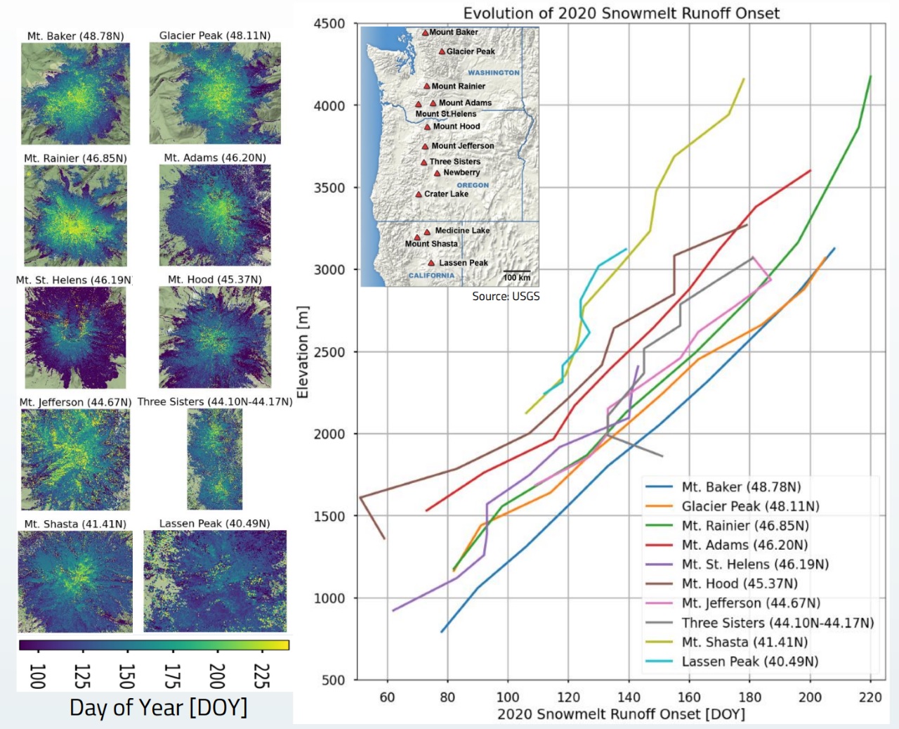
Synthetic Aperture Radar (SAR) microwave instruments on satellites offer high spatial and temporal resolution measurements and provide the ability to delineate between different snowmelt phases. I developed and released an open source toolbox to explore cloud-hosted publicly available Sentinel-1 C-band SAR data and produce snowmelt runoff estimates. This method analyzes the dielectric properties of water in snowpack over time to determine when the snowpack is saturated and runoff onset begins. Before the Incubator program, I had primarily focused on analyzing time series for smaller sites such as the Cascade Range Stratovolcanoes and was able to produce snowmelt runoff onset maps and analyze controls on runoff timing at high resolution (which are currently poorly understood in mountainous areas). The objective of this Incubator project was to scale up the processing of these snowmelt runoff onset maps beyond the current watershed and mountain scale, with a primary goal of processing the full Sentinel-1 catalog (2014-present) to prepare seasonal snowmelt runoff onset maps for the Western U.S.
As a result of the Incubator, we’ve scaled up our processing and improved our method to produce yearly 80m resolution snowmelt runoff onset maps for the contiguous Western U.S. Along with these yearly maps, we’ve produced maps that show interannual variability and median snowmelt values for the entire time series. We’ve created an interactive visualization to preview these maps. Additionally, we compared our results to an automatic weather station network (SNOTEL) to validate our runoff onset estimates and characterize the error of our approach. These products will be valuable for water resource managers to better understand when and where snowpack releases water into critical reservoirs, as well as climate scientists looking to analyze regional trends in snowmelt timing as an indicator of regional climate change.