Project Lead: Lauren Kuntz, Department of Oceanography
eScience Liaison: Rob Fatland, with Purshottam Shivraj
However, our canonical view of how precipitation impacts broad scale atmospheric circulation and energy transport relies on simplified models of the zonal mean; it fails to explain the vertical and meridional variability in precipitation events, as well as their impact on energy fluxes and circulation patterns.
Developing physical theories that capture this variability is immediately relevant to our understanding of regional climate patterns and projecting future changes in response to greenhouse gas forcing.
To address this, we plan to use over 15 years of satellite precipitation data to constrain the different modes of precipitation and their impact vertical energy convergence and divergence.
Using clustering methods, we will determine the dominant modes of precipitation in terms of their energy footprint, allowing us to explore the statistical patterns of these modes spatially and temporally.
With a better sense of where precipitation is driving energy converging and diverging regionally and vertically, we can explore how that fits into the broad scale circulation patterns and atmospheric energy budgets.
We will directly compare climatological means of latent heating from precipitation modes to observations of atmospheric energy flux, developing insight as to how the two are related.
Through this lens, we will also look at the variability of precipitation energy modes across timescales, with the goal of exposing links with circulation and energy transport variability in the atmosphere.
Project Results
Earth’s weather and climate are deeply impacted by the transport of energy through atmospheric circulation. Precipitation is deeply coupled to this system: on one hand, the atmospheric circulation dictates where regions of instability lead to convection, while on the other hand latent heating from precipitation redistributes energy and leads to anomalous circulations. Our canonical view of how precipitation impacts broad scale atmospheric circulation and energy transport relies on simplified models of the zonal mean; it fails to explain the vertical and meridional variability in precipitation events, as well as their impact on regional energy fluxes and circulation patterns. Developing physical theories that capture this variability is immediately relevant to our understanding of regional climate patterns and projecting future changes in response to greenhouse gas forcing.
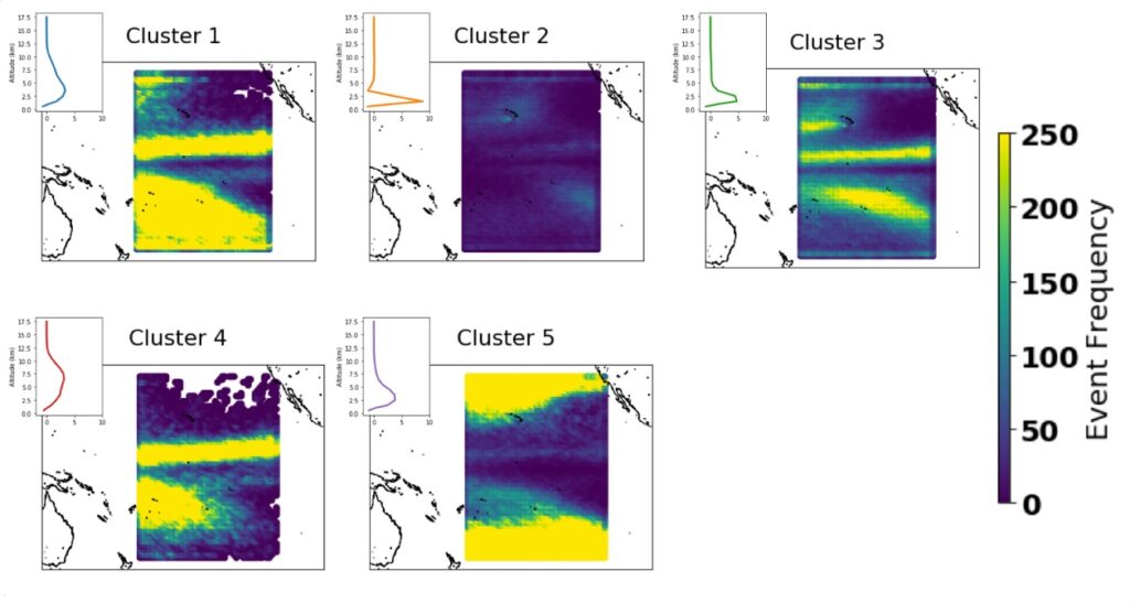
During the incubator, we set out to understand the different modes of precipitation through the lens of their impact on the convergence and divergence of energy using 16 years of satellite data from the Tropical Rainfall Measurement Mission (TRMM). To start, we focused exclusively on the central Pacific region, allowing us to establish a methodology over a subset of the data which can easily be expanded to other regions. We initially grouped observations of precipitation into rain events based on their geospatial structure using the DBSCAN algorithm. Subsequently, we performed kmeans clustering on the mean latent heat profiles of the events to define the various precipitation modes. We then explored how these modes vary in space and time, looking both at the seasonal cycle as well as the variability in relation to other climate forcings, such as ENSO. Given the volume of data, these methods required us to work with cloud computing resources on AWS.
This work easily lends itself to further extensions. Now that the methodology has been refined, it can be expanded to look at the full TRMM dataset. An exploration of monsoon precipitation structure as well as land and ocean differences will be immediate follow on analyses. In addition, incorporating reanalysis data and idealized climate model simulations will allow us to get a better understanding as to how the latent heating structure links back to circulation anomalies. This understanding will also develop further insight as to how precipitation and circulation respond to energy forcings, helping answer long standing questions in the climate community, such as what caused regional rainfall to shift so dramatically in response to precession of Earth’s orbit. Now that the methodology has been established, a series of academic publications are expected as follow-ons.