By Robin Brooks
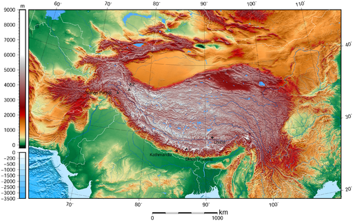
Over one billion people live downstream of the region referred to as High Mountain Asia, an area ranging from the Hindu Kush and Tien Shan in the west to the Eastern Himalaya, and home to “the world’s largest reservoir of perennial glaciers and snow outside of the Earth’s polar ice sheets”. The High Mountain Asia (HMA) Project, led by Anthony Arendt, eScience senior data science fellow and senior research scientist with the UW Polar Science Center at the Applied Physics Laboratory, aims to “generate knowledge on how climate change is impacting the water resources of that region.”
People living in the HMA region depend on the glaciers and snow packs there for freshwater, hydropower and agricultural purposes; however, it is difficult to know what is happening with these water sources because they are hard to get to and governmental data from the region is difficult to obtain. The HMA Project is using several techniques in order to study the area, including photogrammetry (taking multiple pictures from different satellite angles to get a topographical map of the Earth’s surface), laser altimetry (measuring the height of the surface of the Earth using lasers) and satellite gravimetry (directly measuring changes in Earth’s mass caused by variations in the water cycle).
This data is then analyzed and used to do computer simulation modeling and make predictions that will help governments to manage their water resources. By tracking the changes in climate and landscape, the researchers hope to help prevent hazards such as landslides, washed out roads, and flooding.
Funded by NASA, the HMA Project is unique because there was an explicit call for collaboration amongst researchers. Arendt believes he was chosen to lead the thirteen teams of researchers because he had a clear plan to use cloud computing to unify the teams. Using the cloud allows team members to minimize duplication of effort, increases efficiency, allows for reproducibility and enhances cooperation. Rather than each team writing their own codes, they have a centralized repository of scripts that they share.
Recently back from a team meeting in Juneau, AK, Arendt hopes that the project will be a model for future research partnerships. “We think it’s innovative,” he said. “This program was designed in a way to get the data distributed quickly, allowing us to accelerate the science”.
“We’re not just using these data science tools to serve researchers on this team,” Arendt continued, “but they will also impact the broader community. People are beginning to see the benefits of this approach. I feel that this collaborative work is the only way that we can solve these complex Earth science challenges”.